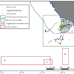
Extreme climatic events are expected to become more frequent under current conditions of increasing global temperatures and climate variability. A key challenge of fisheries management is understanding and planning for the effect of anomalous oceanic conditions on the distributions of protected species and their interactions with fishing gear. Atypical marine states can cause non-target species to shift outside of their normal distribution patterns, leading to unwanted bycatch events that threaten fisheries sustainability. Environmental indicators can serve as early warning signals that allow for proactive management responses before significant bycatch occurs. Marine heatwaves in the Pacific have caused shifts in the distributions of endangered loggerhead turtles (Caretta caretta), increasing overlap with California’s Drift Gillnet fishery and thereby the risk of turtle bycatch events. To reduce bycatch, a fishery closure offshore of Southern California – The Loggerhead Conservation Area – Is enacted when an El Niño event has been declared and local sea surface temperatures (SSTs) are warmer than normal. However, this regulation was based on qualitative assessment of bycatch that occurred during past El Niño events, and no explicit threshold for SST anomalies was defined. Additionally, closures enacted under the current regulation rely on structured expert decision-making. Providing a quantitative indicator could help to refine future decisions. We developed and evaluated potential new indicators to guide the Loggerhead Conservation Area closure timing based on thermal indices in three different regions: the equatorial Pacific, regional areas offshore of Southern California, and temperate pelagic areas off the US west coast. Our objectives were to: 1) quantify thermal indicators and their respective thresholds to guide closure timing, and 2) hindcast closure scenarios based on these indicator thresholds to evaluate efficacy in terms of opportunity costs to fishers and ability to avoid turtle interactions. The best indicator in terms of avoiding historical turtle interactions while minimizing opportunity cost to fishers was a six-month average local SST anomaly indicator with closures enacted above a threshold of 0.77 °C. This result can improve upon the current closure guidelines by providing a quantified and spatially-explicit indicator and threshold to supplement the structured decision-making process. Our analysis demonstrates a novel approach to developing fisheries management strategies for species with a paucity of data. Issues with data comprehensiveness are frequently present in fisheries management exercises, and precautionary approaches are needed to allow adherence with legislation while considering the best available science.
Environmental indicators to reduce loggerhead turtle bycatch offshore southern California
Publication date
March 28, 2019
Abstract
Journal
Ecological Indicators
Region
California Current